Lower Twilight Group Site
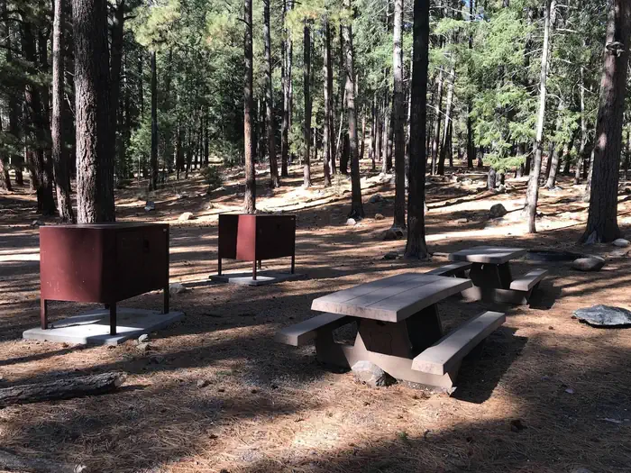
Lower Twilight Group Site
About this campsite
Overview
Lower Twilight Group Site offers groups a secluded camping escape from the summer desert heat. The scenic mountain setting is a great base for hiking, wildlife viewing and picnicking. The facility sits along the Swift Trail in southeastern Arizona, adjacent to Upper Twilight Group Site.
Recreation
The campground lies along the Swift Trail Scenic Drive, which takes visitors from the Sonoran Desert at 2,900 feet to alpine meadows and forest on the 9,000+ foot ridges of the Pinaleño Range. Because of its diverse habitat, the area is well-known for birding and wildlife watching.
The Swift Trail provides access to a number of hiking, horseback riding and mountain biking trails, along with several other campgrounds that invite you for an afternoon picnic. A trip up to Riggs Lake, stocked with trout by Arizona Game & Fish, or to the Columbine Visitors Center could make a worth-while day trip as well.
Facilities
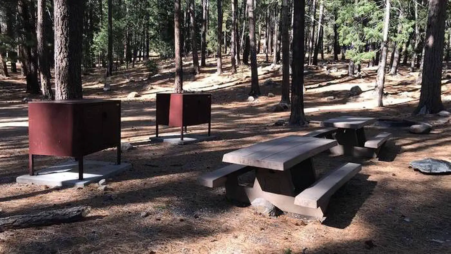
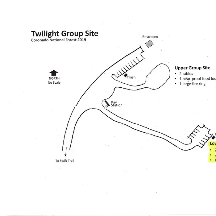
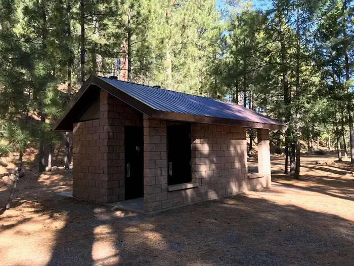
Lower Twilight can accommodate a single group of up to 50 people for camping. Parking is available for up to six vehicles. Amenities include picnic tables, campfire rings with grills, and bear-proof food lockers and trash cans. Vault toilets are located at Upper Twilight Group Site, a short walk away. Dead-and-down firewood may be collected in and around the campsite.
Natural Features
At an elevation of 7,400 feet, the campground lies beneath a nice canopy of ponderosa pine trees in the scenic Pinaleño Mountains in Coronado National Forest. Temperatures are very pleasant in summer compared to the heat of surrounding lowers deserts.
The Coronado National Forest covers 1.78 million acres of southeastern Arizona and southwestern New Mexico. Elevations range from 3,000 to 10,720 feet in 12 widely scattered mountain ranges, or "sky islands," that rise dramatically from the desert floor, supporting biologically diverse plant communities.
Nearby Attractions
The Mount Graham Wilderness Study Area, which includes the 10,720-foot Mount Graham, the tallest mountain in southern Arizona. Columbine Visitors Center, Riggs Lake, and a variety of trails can be accessed along the Swift Trail Scenic Drive.
The town of Safford is approximately a 45 minute drive from the Twilight campground, heading north on SR 191. Safford is home to our Ranger Station, where you can go to find information about trails, camping, hunting and fishing, and other questions you may have about our district (open Monday-Friday, 8am-4:30pm).
Charges & Cancellations
Please review the Rules & Reservations Policies page on recreation.gov
Location
LOWER TWILIGHT GROUP SITE•AZ
Weather Forecast
via Open-MeteoNearby Campsites
 900m away
AZ
UPPER ARCADIA
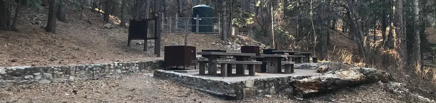
Overview Upper Arcadia sits along Swift Trail in southeastern Arizona, providing an escape from desert heat and a pleasant place to take in the high desert scenery in spring and fall. Visitors enjoy hiking, camping, birding and picnicking. Recreation The campground lies along the Swift Trail Scenic Drive, which takes visitors from the Sonoran Desert at 2,900 feet to alpine meadows and forest on the 9,000+ foot ridges of the Pinaleño Range. Because of its diverse habitat, the area is well-known for birding and wildlife watching. The Swift Trail provides access to a number of hiking, horseback riding and mountain biking trails, along with several other campgrounds that invite you for an afternoon picnic. A trip up to Riggs Lake, stocked with trout by Arizona Game & Fish, or to the Columbine Visitors Center could make a worth-while day trip as well. The Arcadia Trail #328 starts at the Upper Arcadia Campground and leads up the mountain to Shannon Campground. A 1-mile spur off this trail leads to the top of Heliograph Peak, one of the highest mountains in southeastern Arizona. Facilities The group camping area can accommodate up to 75 people. Amenities include drinking water (available seasonally), vault toilets, picnic tables, and campfire rings with grills. Bear-proof food lockers and trash cans are provided to keep visitors and wildlife safe. Dead-and-down firewood may be collected in and around the campsite. Several first-come, first-served sites are located nearby (must pay separately). Natural Features The shady campground is in a thick forest of tall ponderosa pines interspersed with Gambel oaks and Arizona walnuts, at an elevation of 6,700 feet. The Coronado National Forest covers 1.78 million acres of southeastern Arizona and southwestern New Mexico. Elevations range from 3,000 to 10,720 feet in 12 widely scattered mountain ranges, or "sky islands," that rise dramatically from the desert floor, supporting biologically diverse plant communities. Nearby Attractions The Mount Graham Wilderness Study Area, which includes the 10,720-foot Mount Graham, the tallest mountain in southern Arizona. Columbine Visitor Center, Riggs Lake, and a variety of trails can be accessed along the Swift Trail Scenic Drive. The town of Safford is approximately a 30 minute drive from the Upper Arcadia campground, heading north on SR 191. Safford is home to our Ranger Station, where you can go to find information about trails, camping, hunting and fishing, and other questions you may have about our district (open Monday-Friday, 8am-4:30pm). Charges & Cancellations Please review the Rules & Reservations Policies page on recreation.gov
 3.4 km away
AZ
Shannon Campground
Campground: Shannon Campground. Operated by USFS.
4.7 km awayAZ
TREASURE PARK - NORTH
Overview Treasure Park North sits along the scenic Swift Trail in southern Arizona. The picturesque mountain meadow setting provides an escape from the desert heat and opportunities for viewing wildlife and wildflowers, as well as group camping, hiking, mountain biking and picnicking. The location boasts an interesting history. Legend has it that a treasure of stolen gold and silver was buried here by a band of outlaws in the 1850s. They reportedly marked the site with a triangle formed by three colored granite stones, though no buried treasure was ever found. Recreation The campground lies along the Swift Trail Scenic Drive, which takes visitors from the Sonoran Desert at 2,900 feet to alpine meadows and forest on the 9,000+ foot ridges of the Pinaleño Range. Because of its diverse habitat, the area is well-known for birding and wildlife watching. The Swift Trail provides access to a number of hiking, horseback riding and mountain biking trails, along with several other campgrounds that invite you for an afternoon picnic. A trip up to Rigg’s Lake, stocked with trout by Arizona Game & Fish, or to the Columbine Visitors Center could make a worth-while day trip as well. Facilities Treasure Park North can accommodate a single group of up to 100 people at a time. The site is equipped with picnic tables, a group campfire ring with grill, a parking area and a drinking water spigot nearby, with water available seasonally. Dead-and-downed firewood may be collected in and around the campsite. Note: There are no toilets on site. One portable/self-contained toilet is required for every 15 people. Natural Features This site lies within the mixed conifer area of the Pinaleño Mountains at an elevation of 9,000 ft. The high elevations makes this area very pleasant in summer compared to the heat of lower deserts. The Coronado National Forest covers 1.78 million acres of southeastern Arizona and southwestern New Mexico. Elevations range from 3,000 to 10,720 feet in 12 widely scattered mountain ranges, or "sky islands," that rise dramatically from the desert floor, supporting biologically diverse plant communities. Nearby Attractions The Mount Graham Wilderness Study Area, which includes the 10,720-foot Mount Graham, the tallest mountain in southern Arizona. Columbine Visitors Center, Riggs Lake, and a variety of trails can be accessed along the Swift Trail Scenic Drive. The town of Safford is approximately a 1 hour drive from the Treasure Park campground, heading north on SR 191. Safford is home to our Ranger Station, where you can go to find information about trails, camping, hunting and fishing, and other questions you may have about our district (open Monday-Friday, 8am-4:30pm). Charges & Cancellations Please review the Rules & Reservations Policies page on recreation.gov
 4.7 km away
AZ
TREASURE PARK - EAST
Overview Treasure Park East sits along the scenic Swift Trail in the deserts of southern Arizona. The picturesque mountain meadow setting offers visitors an escape from the desert heat and opportunities for viewing wildlife and wildflowers, as well as group camping, hiking, mountain biking and picnicking. The location boasts an interesting history. Legend has it that a treasure of stolen gold and silver was buried here by a band of outlaws in the 1850s. They reportedly marked the site with a triangle formed by three colored granite stones, though no buried treasure was ever found. Recreation The campground lies along the Swift Trail Scenic Drive, which takes visitors from the Sonoran Desert at 2,900 feet to alpine meadows and forest on the 9,000+ foot ridges of the Pinaleño Range. Because of its diverse habitat, the area is well-known for birding and wildlife watching. The Swift Trail provides access to a number of hiking, horseback riding and mountain biking trails, along with several other campgrounds that invite you for an afternoon picnic. A trip up to Rigg’s Lake, stocked with trout by Arizona Game & Fish, or to the Columbine Visitors Center could make a worth-while day trip as well. Facilities Treasure Park East can accommodate a single group of up to 100 guests at a time. The site is equipped with picnic tables, a group campfire ring with grill, a parking area and a drinking water spigot nearby, with water available seasonally. Dead-and-downed firewood may be collected in and around the campsite. Note: There are no toilets on site. One portable/self-contained toilet is required for every 15 people. Natural Features This site lies within the mixed conifer area of the Pinaleño Mountains at an elevation of 9,000 feet. The high elevations makes this area very pleasant in summer compared to the heat of lower deserts. The Coronado National Forest covers 1.78 million acres of southeastern Arizona and southwestern New Mexico. Elevations range from 3,000 to 10,720 feet in 12 widely scattered mountain ranges, or "sky islands," that rise dramatically from the desert floor, supporting biologically diverse plant communities. Nearby Attractions The Mount Graham Wilderness Study Area, which includes the 10,720-foot Mount Graham, the tallest mountain in southern Arizona. Columbine Visitors Center, Riggs Lake, and a variety of trails can be accessed along the Swift Trail Scenic Drive. The town of Safford is approximately a 1 hour drive from the Treasure Park campground, heading north on SR 191. Safford is home to our Ranger Station, where you can go to find information about trails, camping, hunting and fishing, and other questions you may have about our district (open Monday-Friday, 8am-4:30pm). Charges & Cancellations Please review the Rules & Reservations Policies page on recreation.gov
 5.2 km away
AZ
UPPER HOSPITAL FLAT GROUP SITE
Overview Upper Hospital Flat is a great place for groups to escape the summer heat of surrounding deserts and retreat to a scenic meadow in the Pinaleño Mountains of southeastern Arizona. The area is known for camping, scenic driving, picnicking, birding, wildlife viewing, hiking, mountain biking and history. In the 1880s, the campground served as the site for a field hospital for ailing soldiers from nearby Fort Grant, hence its name. The restorative powers of this cool, high-elevation location also attracted officers and their families seeking a summer refuge from desert heat. Today, Hospital Flat serves as popular getaway for outdoor enthusiasts and campers. Recreation The campground lies along the Swift Trail Scenic Drive, which takes visitors from the Sonoran Desert at 2,900 feet to alpine meadows and forest on the 9,000+ foot ridges of the Pinaleño Range. Because of its diverse habitat, the area is well-known for birding and wildlife watching. Nearby Hospital Flat Campground includes a 0.75-mile nature trail that gives interpretive information about the meadow and its plant and animal inhabitants. The Swift Trail also provides access to a number of hiking, horseback riding and mountain biking trails, along with several other campgrounds that invite you for an afternoon picnic. A trip up to Rigg’s Lake, stocked with trout by Arizona Game & Fish, or to the Columbine Visitors Center could make a worth-while day trip as well. Facilities Upper Hospital Flat can accommodate a group of up to 50 people. Several first-come, first-served individual sites are located nearby in the Hospital Flat Campground (must pay separately). The group site is equipped with a picnic table, parking area and campfire ring with a grill. Dead-and-down firewood may be collected in and around the campsite. Note: There are no toilets on site. One portable/self-contained toilet is required for every 15 people. The road leading into the group site is mainly suitable for higher-clearance vehicles. Natural Features The campground sits along Big Creek in a mixed conifer forest, adjacent to a meadow that comes to life with wildflower blooms in late summer. The 9,000-ft. elevation offers pleasant summer temperatures. The Coronado National Forest covers 1.78 million acres of southeastern Arizona and southwestern New Mexico. Elevations range from 3,000 to 10,720 feet in 12 widely scattered mountain ranges, or "sky islands," that rise dramatically from the desert floor, supporting biologically diverse plant communities. Nearby Attractions The Mount Graham Wilderness Study Area, which includes the 10,720-foot Mount Graham, the tallest mountain in southern Arizona. Columbine Visitors Center, Riggs Lake, and a variety of trails can be accessed along the Swift Trail Scenic Drive. The town of Safford is approximately a 1 hour drive from the Hospital Flat campground, heading north on SR 191. Safford is home to our Ranger Station, where you can go to find information about trails, camping, hunting and fishing, and other questions you may have about our district (open Monday-Friday, 8am-4:30pm). Charges & Cancellations Please review the Rules & Reservations Policies page on recreation.gov
 Britz HiTopCampervan
 Maui UltimaCampervan
 Jucy CoasterCampervan
Hitting the road? Rent the rig, not just the gear.
Compare live prices across Britz, Maui, Apollo, Jucy & more — campervans and motorhomes, one-way hires included.
Compare & bookPlan your visit
Save it, check the weather, map your route
Nearby Fuel
Campsite Explorer
Find Your Next Campsite
Share Your Experience
Help fellow campers by sharing your photos and reviews.
Own This Campsite?
Claim your listing to manage information, respond to reviews, and update details.
LOWER TWILIGHT GROUP SITE